
MATCH YOUR PROJECT WITH THE RIGHT SERVICE
Schedule a consultation to discuss your project goals, site conditions, and service needs. We'll help you identify the right solution and next steps for your operation.
AERIAL IMAGERY
RGB & THERMAL INSPECTIONS
SURVEYING & MAPPING

Gain a broader view of your project through high-resolution still imagery, video, and thermal captures delivered in clear, ready to use formats.
SURVEYING & MAPPING
RGB & THERMAL INSPECTIONS
SURVEYING & MAPPING

Turn complex sites into clear, actionable data for planning, analysis, and project execution, while improving safety and reducing jobsite risk.
RGB & THERMAL INSPECTIONS
RGB & THERMAL INSPECTIONS
RGB & THERMAL INSPECTIONS
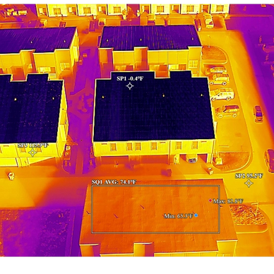
Reduce jobsite risk while gaining detailed insight needed to monitor and maintain critical equipment and structures, with faster inspections that help minimize downtime and keep operations on track.
EMERGENCY & DISASTER
EMERGENCY & DISASTER
RGB & THERMAL INSPECTIONS
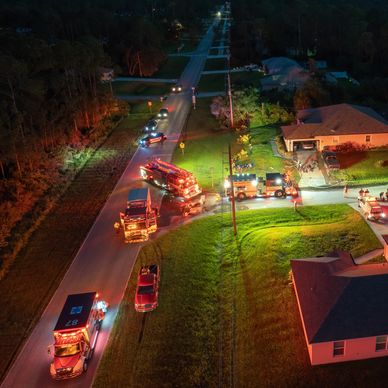
We provide rapid aerial support during emergency and disaster situations by helping teams assess conditions, document damage, and gain safer, faster situational awareness from above.
VOLUMETRICS
EMERGENCY & DISASTER
VOLUMETRICS

Capture volumetric data that can be processed into accurate 3D models used to calculate stockpile, excavation, and site volumes.
FARM-VIEW
EMERGENCY & DISASTER
VOLUMETRICS
We give farmers a faster way to see drainage issues, crop damage, livestock/wildlife activity, and field conditions from above, before small problems become expensive ones.
LIVESTOCK MONITORING
PREDATOR CONTROL & GAME RECOVERY
PREDATOR CONTROL & GAME RECOVERY
Aerial drone imagery helps ranchers and producers monitor land and livestock more efficiently, using reliable data to improve resource management, reduce costs, and support smarter operational decisions.
PREDATOR CONTROL & GAME RECOVERY
PREDATOR CONTROL & GAME RECOVERY
PREDATOR CONTROL & GAME RECOVERY
Quickly detect targets in darkness, brush, and heavy cover without disrupting the area. Speeds up game recovery by helping locate downed animals and reacquire the herd immediately after a shot, reducing wasted time and increasing recovery success.